The salt works hypothesis is the proposal that the engineered structures beneath the beach at Smith's Cove on Oak Island are not the feeders of an artificial flood tunnel built to protect a buried treasure, but the surviving infrastructure of a clandestine salt-making operation from the mid-eighteenth century. Its purpose, on this reading, was the preservation of fish caught on the Atlantic coastal fisheries. The theory addresses Smith's Cove alone. It does not attempt to explain the Money Pit.
 Down the Money Pit→
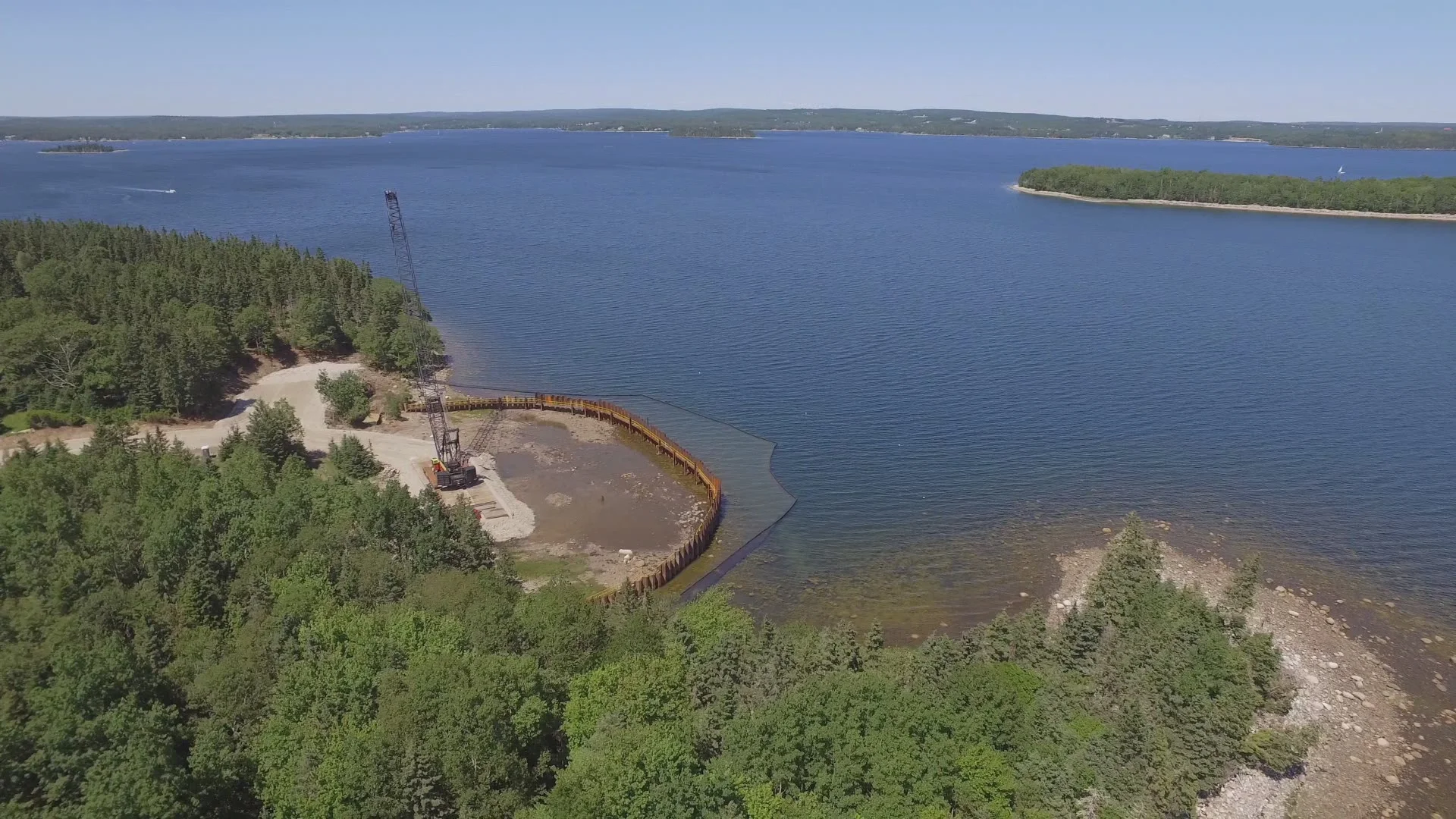 Smith's Cove→
The Source
The hypothesis was advanced by Dennis J. King in a 2010 article titled "A Solution to the Mystery of the Oak Island Five Finger Drains," published on Richard Joltes's Critical Enquiry website. King had previously argued that the same drains were a freshwater works for early colonists, an idea he posted to the Oak Island Treasure Forum in July 2005, but he abandoned that earlier theory in the 2010 paper. The 2010 article remains the only published source-of-record for the salt interpretation. The Curse of Oak Island has not engaged with the theory on screen, and no book-length treatment has appeared since.
The Proposed Mechanism
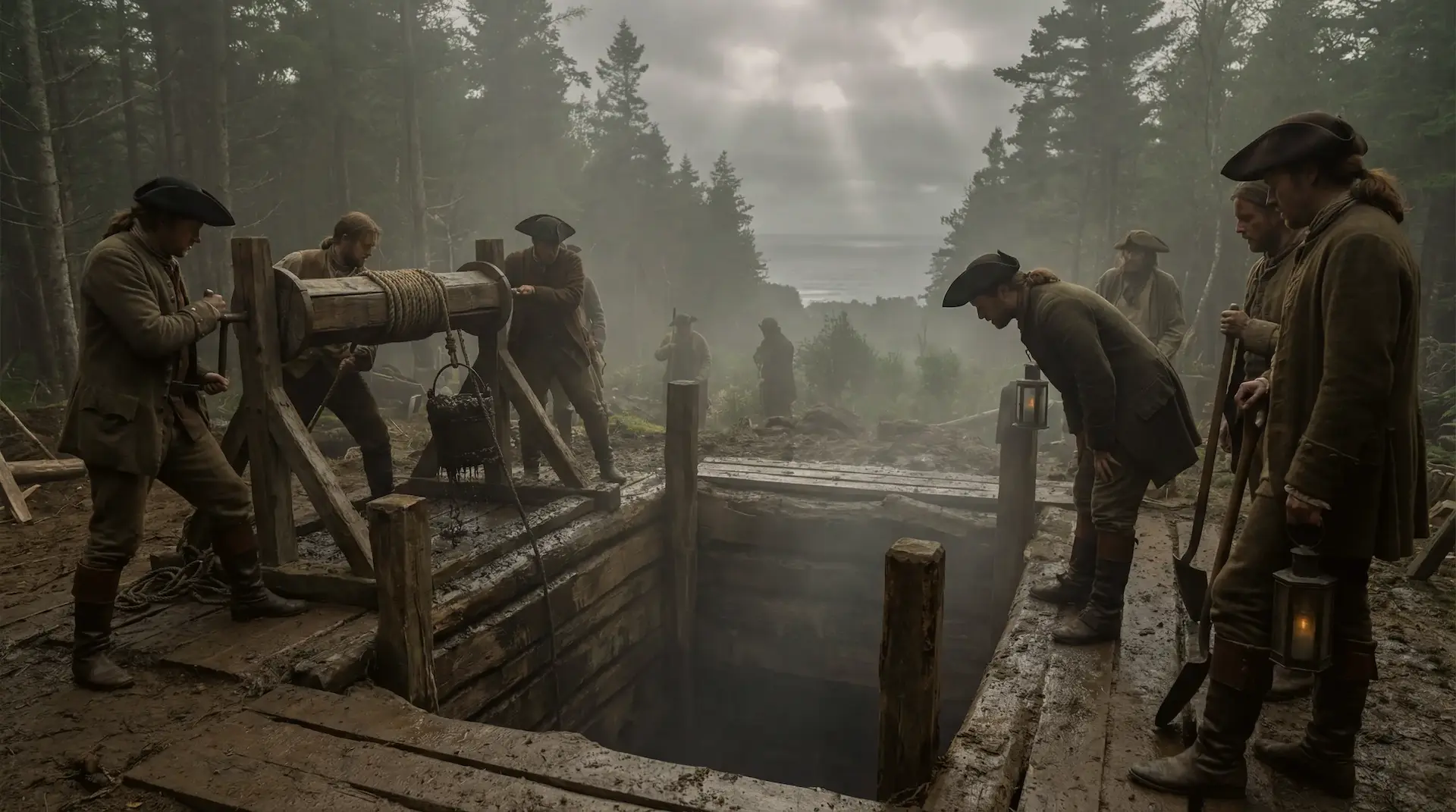
King's reconstruction works as follows. A cofferdam was built across the beach to hold back the tide. Inside it, the operators excavated the natural beach to a depth of about five feet, laid five converging stone drains running from the dam toward a common point near the high-water mark, and covered the drains with beach rocks. Above the rocks they placed a layer of eelgrass and a layer of coconut husk, then capped the whole construction with about two feet of sand. A stone-lined well at the convergence of the drains served as a collection sump.
A natural saltwater spring on the beach, recorded in the Colonist on 2, 7, and 14 January 1864, and rediscovered by Daniel Blankenship in September 1970, supplied brine to the sand. Controlled inundations of seawater through the dam supplemented it. Sun and wind dried the sand, leaving salt behind. After repeated cycles, a single larger inundation dissolved the accumulated salt back out of the sand and carried the concentrated brine through the eelgrass and coconut filter into the well. The brine was then transferred to a fire pit for boiling.
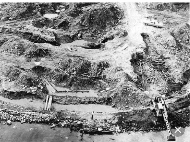
King identifies that fire pit with the U-shaped concrete foundation Blankenship excavated in November 1969, located about 150 feet south of the centre of the Smith's Cove beach. Blankenship's report described the structure as twelve feet wide and twenty-five feet long, with the seaward end open, footings averaging three feet deep, and stones cemented together. He recorded that the earth inside showed extensive heat damage and was burnt deep red, with charcoal and coal present. King draws a direct parallel with the East Anglian salt-making sites in England, known to this day as "Red Hills" because the soil where seawater was once boiled is burnt the same colour.
 U-shaped wooden structure→
The Historical Case
The first recorded owners of Oak Island were John Gifford and Richard Smith, New York fish merchants who received a grant of three islands in Mahone Bay on 27 December 1753. The Halifax Gazette of 4 May 1754 reported that the company had arrived "with men and supplies to commence fishing and farming." King proposes Gifford and Smith, or operators connected with their fishing enterprise, as the most plausible builders of the salt works.
Salt was essential to the operation. Refrigeration did not exist. The only practical way to preserve fish caught on the Grand Banks for shipment back to Europe or to the New England colonies was salting and drying. Salt was also expensive and heavily taxed. The British salt tax was not repealed until 1835, and the French salt duty known as the Gabelle was so onerous that historians count it among the immediate causes of the 1789 Revolution. King argues that the absence of any documentary record of an Oak Island salt operation is consistent with deliberate concealment to evade duty.
Technical Precedents
King cites three pre-industrial methods of salt manufacture from concentrated brine. In Normandy, as recorded by Professor John Le Conte in 1862, beach sand was repeatedly soaked by the tide, dried, and removed to pits where seawater dissolved the accumulated salt. The Japanese Channelled Salt Terrace method, known as Irihamashiki-Enden, used the same principle in reverse: a sand-floored terrace below high tide, kept dry by a dyke, was periodically flooded through controlled channels and dried by sun and wind. In medieval Holland, as documented by Bas van Geel and Guus Borger in the Netherlands Journal of Geosciences in 2005, eelgrass was harvested, burned, and the salt-rich ashes leached with seawater to produce a concentrated brine. King argues that the Smith's Cove arrangement is in effect a refinement of these systems, with the salt-laden sand left in place and the concentrated brine drawn off through the drains rather than scooped up and transported to a separate vat.
Why the Flood-Tunnel Premise Matters
The salt hypothesis only stands if the alleged artificial flood tunnel between Smith's Cove and the Money Pit is a myth. If the drains feed a flood tunnel, they cannot also be the sump of a salt works. King relies on the work of Robert Dunfield, a Californian geologist who carried out extensive excavations on the island in 1965 and 1966. Dunfield found no flood tunnel either at the Money Pit or in the Cave-In Pit on the supposed line of the tunnel. He concluded that water entering the Pit came from the Windsor limestone formation, which intersects the bedrock surface at about 140 feet beneath the Money Pit and is honeycombed with natural cavities. The 1937 Heddon shaft, dug to 125 feet on the east side of the Money Pit, and the 1862 tunnel cut by the Oak Island Association, both crossing the supposed flood-tunnel line at depth, found nothing. The 1995 Woods Hole Oceanographic Institution side-scan sonar survey of the area between cove and Pit found no channel. Tides at Oak Island swing about nine feet between high and low water, but the water level in the Money Pit reportedly rose and fell only about eighteen inches with the tide, which King reads as more consistent with natural percolation through bedrock than a free connection to the sea.
 Oak Island Flood Tunnels and Box Drains: The Water Trap→
Physical Evidence at Smith's Cove
Three pieces of physical evidence at Smith's Cove are consistent with King's reconstruction. The saltwater spring on the beach, recorded in 1864 and rediscovered in 1970, supplies the brine source. The 25-foot dead-end well at the drain convergence, excavated by Dunfield in the mid-1960s and described by him as leading to no flood tunnel, supplies the collection sump. The U-shaped concrete foundation 150 feet south, with its burnt-red interior soil and charcoal residues, supplies the boiling site.
Robert Restall's 1961 progress report to landowner Mel Chappell, after he and his son Bobby had dug 65 exploratory holes between two and six feet deep, described the artificial beach as 243 feet long along the inner edge of the cofferdam. The Truro Company in 1850 had reported a length of about 145 feet. The larger Restall figure suggests a more extensive operation than the original nineteenth-century accounts captured.
 The Chappell Family and the Vault Beneath Oak Island→
 The Restall Tragedy→
Below the Salt
No documentary record of a salt-making operation on Oak Island has been found in British colonial papers or in the records of the South Sea Company. King's explanation, that the operation was clandestine and tax-driven, is plausible but unproveable. No chemical or residue analysis has been performed on the Smith's Cove sand layers or the burnt soil inside the U-shaped foundation to test for sodium chloride concentrations.
The identification of the U-shaped foundation as a salt-boiling site is analogical. The East Anglian Red Hills parallel is suggestive but not definitive. The structure could equally be a fire pit for fish drying, a forge, or a feature from a later searcher encampment.
The radiocarbon dating of coconut fibre samples from Smith's Cove to between 1260 and 1400 AD, if the dates are accurate and the samples uncontaminated, places the fibre layers centuries before any plausible eighteenth-century salt operation. King's article predates these results and does not address them. The hand-wrought iron scissors that Blankenship recovered from beneath one of the drains, examined by former Smithsonian Institution Historical Archeology curator Mendel Peterson and identified as Spanish-Mexican work of the mid-to-late 1600s, are also difficult to reconcile with a 1750s construction date.
The hypothesis is silent on the Money Pit itself. The deep wood platforms reported by the early companies, the inscribed stone said to have been recovered at 90 feet, the metal layer struck by drilling at depth in 1849, and the broader pattern of finds in the Pit are outside its scope.
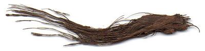 Coconut fibre (Smith's Cove)→
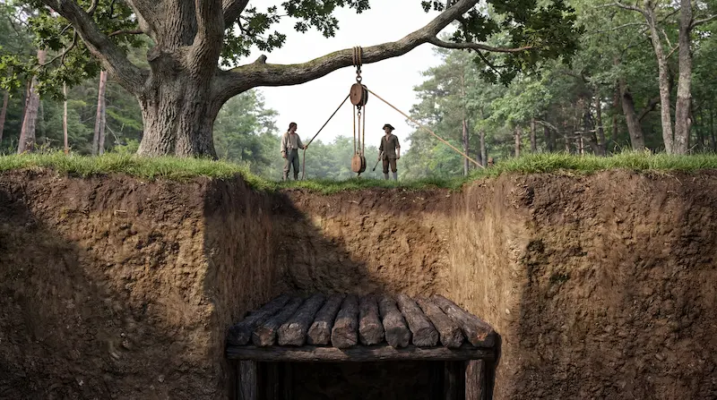 Oak log platforms (multiple)→
Assessment
The salt works hypothesis is a coherent mundane explanation for the Smith's Cove drains, the artificial beach, and the U-shaped concrete foundation, set within a defensible window of operation under known eighteenth-century technology. It depends on the flood tunnel being a natural rather than artificial feature, a position supported by the Dunfield, Heddon, Oak Island Association, and Woods Hole evidence but contested by treasure-hunting investigators who continue to read the same evidence differently. It is not a theory of Oak Island. It addresses one feature on one shore.
Sources
- Primary source for the theory: Dennis J. King, "A Solution to the Mystery of the Oak Island Five Finger Drains," March 2010, hosted on Richard Joltes's Critical Enquiry website at King's earlier freshwater hypothesis appeared as a post on the Oak Island Treasure Forum dated 3 July 2005.
- Documentary records: Halifax Gazette, 4 May 1754, on the Gifford and Smith fishing enterprise. Colonist (Halifax), 2 January 1864, 7 January 1864, and 14 January 1864, on the Smith's Cove saltwater spring. The grant of three islands in Mahone Bay to John Gifford and Richard Smith is dated 27 December 1753.
- Excavation reports: Daniel Blankenship, "Results of digging done in Smiths Cove, November 1969," on the U-shaped concrete foundation. Daniel Blankenship, "Summary of work performed at Smiths Cove, August 31 to September 18, 1970," on the rediscovered saltwater spring. Robert Dunfield, sketch dated 25 July 1965, memorandum dated 8 February 1967, letter to R.V. Harris dated 7 November 1966, and letter to D'Arcy O'Connor dated 21 October 1976, on the absence of an artificial flood tunnel. Robert Restall, progress report to Mel Chappell, 1961, on the 243-foot extent of the Smith's Cove beach work.
- Books: Randall Sullivan, The Curse of Oak Island: The Story of the World's Longest Treasure Hunt (Atlantic Monthly Press, 2018), for the Restall report and the Mendel Peterson identification of the Smith's Cove scissors. Graham Harris and Les MacPhie, Oak Island and Its Lost Treasure (Formac, 1999), for the 1937 Heddon shaft and 1862 Oak Island Association tunnel.
- Technical and historical precedents: John Le Conte, "On the Manufacture of Salt by Solar Evaporation," 1862, on the Normandy lixiviating-saline-sand method. Salt Industry Centre of Japan reference works on the Irihamashiki-Enden channelled-terrace method. Bas van Geel and Guus Borger, "Sources of salt in the early Middle Ages," Netherlands Journal of Geosciences 84-1 (2005), on medieval Dutch eelgrass salt-making.
- Other physical evidence: Woods Hole Oceanographic Institution side-scan sonar survey, 1995, finding no channel between Smith's Cove and the Money Pit. Coconut fibre radiocarbon dating to 1260 to 1400 AD reported on the History Channel Curse of Oak Island interactive map.