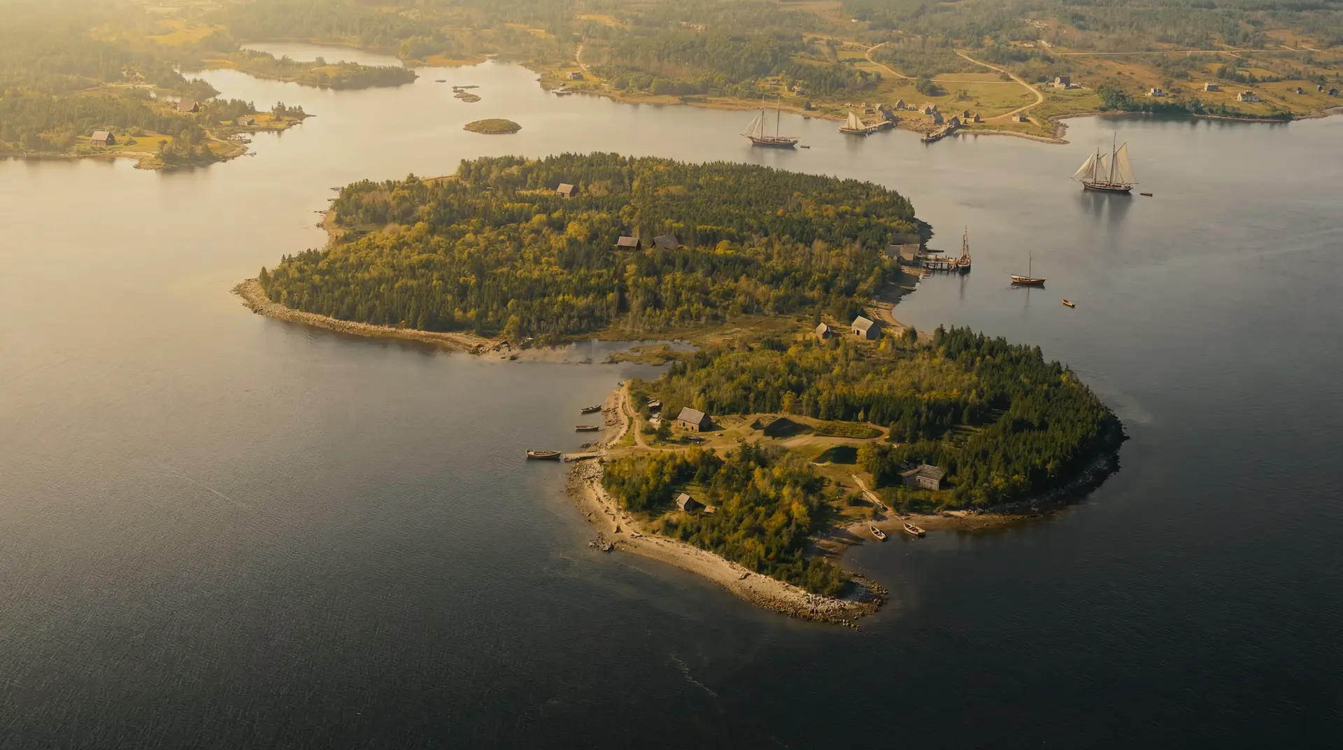
Oak Island is small. Just 140 acres of glacial drumlins rising from Mahone Bay, Nova Scotia, connected to the mainland by a causeway built in 1965. From the air it looks like dozens of other islands dotting this stretch of the Atlantic coast. But beneath its surface lies an engineering mystery that has baffled searchers for over two centuries.
Geography of a Mystery
The island sits roughly 200 meters off the shore of the mainland, in a bay that contains over 350 islands. The Mi'kmaq people, who have inhabited Nova Scotia for thousands of years, called it Wna'kat, meaning "island of foam." European settlers named it Oak Island for the slender red oak trees with characteristic umbrella canopees that once covered its eastern end, trees that have long since been cut down during various excavation attempts.
The island measures roughly 1 kilometer long and 400 meters at its widest point. Its terrain is characterized by two drumlins, oval hills formed by glacial deposits, with a swampy depression running between them. The highest point rises about 35 feet above sea level.
For treasure hunters, the geography presents both opportunity and obstacle. The island is small enough to search systematically, but its glacial soil is unstable, prone to flooding, and riddled with natural cavities that complicate any excavation.
The Money Pit Area
The eastern end of the island contains the famous Money Pit, the original shaft discovered in 1795. Or at least it did. After 230 years of excavation, the precise location of the original pit has been lost. Dozens of shafts have been dug, collapsed, refilled, and dug again. The area now resembles a churned battlefield.
What we know is that the original pit was located beneath a large red oak tree. A ship's tackle block hung from a sawed off branch directly above a circular depression in the ground. The tree is long gone, cut down in the early 1800s, and its exact location has been debated ever since.
Modern surveys using ground penetrating radar and seismic imaging have revealed a complex network of cavities and voids beneath this area. The original builders created something far more extensive than a simple shaft. By now it is impossible to say what is natural, what is original work and what has been created by more than 200 years of searching under the island.
Smith's Cove
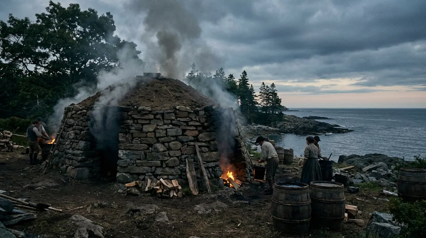
On the northeastern shore lies Smith's Cove, perhaps the most important location on the island after the Money Pit itself since it is a great natural harbour. Here, in 1850, searchers discovered an artificial beach: a layer of coconut fiber and eel grass covering five stone box drains, all feeding into a flood tunnel that ran 500 feet inland to the Money Pit.
The engineering was remarkable. The box drains acted as filters, allowing seawater to flow while preventing sand from clogging the system. The coconut fiber, which could not have originated anywhere near Nova Scotia, was specifically chosen for its resistance to rot in salt water.
Beneath the artificial beach, workers in 1970 discovered a U-shaped structure: massive logs, some 30 to 65 feet long, notched with Roman numerals and arranged in a U formation. Carbon dating placed the logs around 1720, seventy five years before the Money Pit's official discovery. Someone was building here long before Daniel McGinnis arrived.
Smith's Cove also yielded important artifacts: wrought iron scissors identified by the Smithsonian as Spanish American and roughly 300 years old, a heart shaped stone, and fragments of old wharves or slipways suggesting the cove once served as a working harbor.
The Swamp
Between the two drumlins lies a triangular swamp that most early searchers ignored. Recent investigation suggests this was a mistake. Ground penetrating radar has revealed anomalies beneath the swamp perhaps consistent with a ship or large wooden structure buried in the muck.
The swamp has yielded significant finds: a Spanish maravedi coin dated 1652, hand forged nails, and wooden planking that may be ship's timbers. Some researchers now believe the swamp is not natural at all, but was created deliberately by damming a former cove, possibly to conceal evidence of earlier activity on the island.
If a ship lies buried in the swamp, it would explain how the original depositors transported the massive quantities of material needed to construct the Money Pit: the oak platforms, the tons of coconut fiber, the engineering equipment. They may have sailed directly to the site, then sunk their own vessel to hide the evidence.
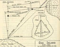
The South Shore
The south shore of Oak Island has received less attention than the Money Pit area, but it holds its own secrets. Dye tests in the 1890s revealed a possible second flood tunnel originating from this shore, providing redundant protection for the Money Pit. Block one tunnel, and the other continues flooding the shaft.
In 1965, workers discovered an unmarked shaft on the south shore beach: eight feet in diameter, 45 feet deep, with no wooden cribbing, predating any known excavation. Someone had dug here before 1795, for reasons that remain unknown.
The south shore also offers the best view of the Frog Island drumlin, a small island 300 meters offshore that some researchers believe may have served as a lookout point or secondary depot for the original depositors.
Nolan's Cross
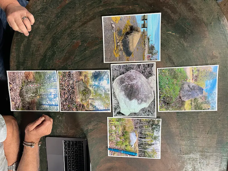
Fred Nolan, a surveyor who spent over 50 years searching Oak Island, made a discovery in 1992 that changed how researchers view the island's geography. Using survey equipment, he identified five large granite boulders arranged in a perfect cross formation, 867 feet from tip to tip.
The boulders were not native to Oak Island. They had been transported from elsewhere and placed with precision. The cross sits 60 degrees off true north and, according to Nolan, points to significant locations on the island. Whether it marks a burial site, serves as a survey marker, or has religious significance remains debated.
Nolan's Cross suggests that whoever used Oak Island did not merely dig a single pit. They surveyed the entire island and marked it according to a deliberate plan. In recent years, by analyzing the cross’s star alignments, renowned Italian archaeo-astronomer Adriano Gaspani has dated Nolan’s Cross to 1200 AD.
The Stone Triangle
In 1937, Gilbert Hedden's workers discovered a stone triangle on the island's surface: a perfect equilateral triangle made of beach stones, ten feet on each side. A medial line pointed true north, directly toward the Money Pit.
Two drilled rocks were found 415 feet apart on an east-west line, possibly serving as additional survey markers. Together with the triangle, they suggested the original depositors left a system for relocating the treasure.
Tragically, the stone triangle was destroyed in 1965 during Robert Dunfield's careless excavation. It exists now only in photographs and survey notes. Whatever message it contained is lost forever.
 Stone Triangle→

The War Room
Modern searchers operate from a research center known as the War Room, a building on the island that serves as command center for the ongoing excavation. Here, the team analyzes finds, reviews data from ground penetrating radar and seismic surveys, and plans each season's work.
The War Room represents how much the search has changed since Daniel McGinnis arrived with a shovel. Today's treasure hunters deploy million dollar equipment, consult with experts worldwide via video link, and document every discovery for scientific analysis. Oak Island has become as much an archaeological and archival research project as a treasure hunt.
An Island Transformed
Oak Island today bears little resemblance to the wilderness Daniel McGinnis explored in 1795. The red oaks are gone. The Money Pit area has been excavated dozens of times. A causeway connects the island to the mainland. Buildings, roads, and heavy equipment cover what was once untouched forest.
But beneath the surface, the mystery remains. Tunnels still flood with seawater. Chambers still lie unexplored. The original engineers built their vault to last centuries, and it has. Whatever secrets Oak Island holds, the island itself is not yet ready to give them up.