The Flooding
Every expedition that has dug into the Money Pit has encountered the same problem. At roughly 90 to 100 feet, seawater pours in. The water level rises and falls with the tide, proving it is connected to the ocean. Pumps that can handle hundreds of gallons per minute fail to keep up. In 1938, engineer Edwin Hamilton measured water entering the Hedden shaft at approximately 800 gallons per minute. No one has managed to stop it in over 230 years.
The standard explanation, repeated in nearly every account since the 1850s, is that this flooding is deliberate: that whoever built the Money Pit also engineered tunnels and drains to channel the Atlantic into any shaft that reaches a certain depth, creating an impenetrable watery booby trap. The physical evidence behind this claim is spread across Smith's Cove, the south shore, and the Money Pit itself. Some of it is solid. Some of it is inference. Some of it has never been verified at all.
The Artificial Beach at Smith's Cove
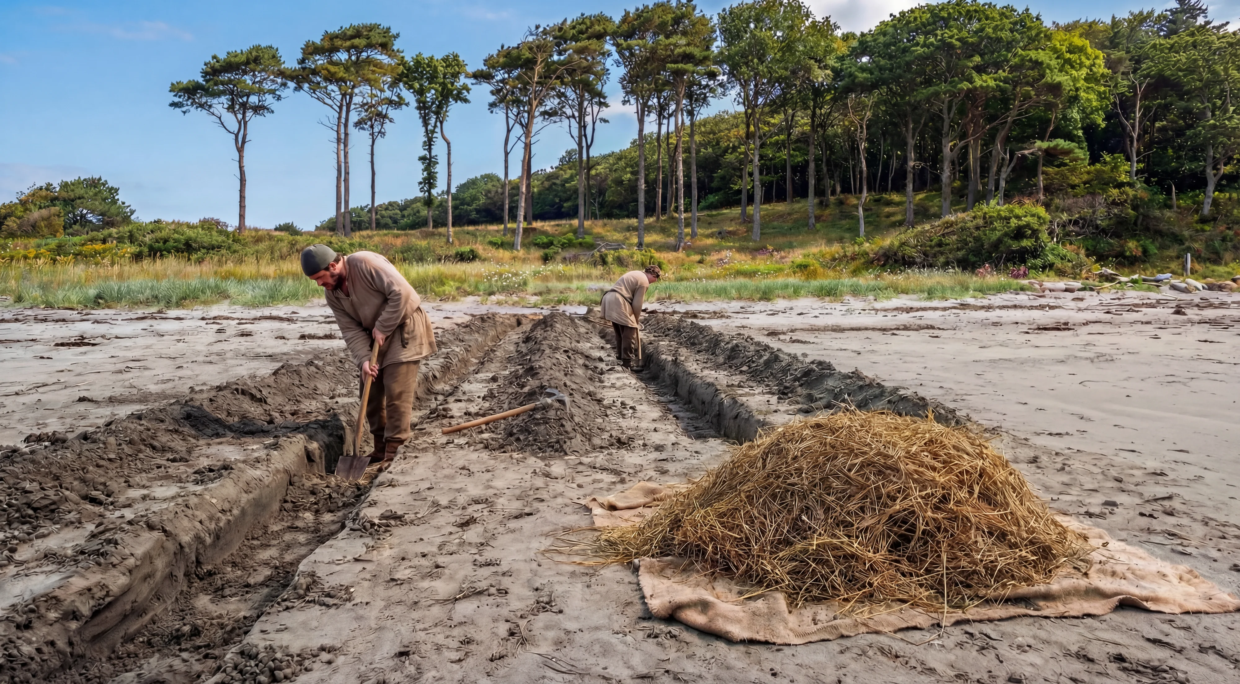
In 1850, the Truro Company began investigating the source of the flooding. Workers had observed that seawater in the Money Pit rose and fell with the tide, ruling out an underground spring. At Smith's Cove, on the island's eastern shore, they noticed water trickling from the beach at low tide in a way that did not match normal drainage. They began digging.
Three feet below the surface, the crew found a layer of brown fibrous material roughly two inches thick. Below it lay a thicker layer of decayed eelgrass. Tons of this material were pulled away and stacked along the shore. Beneath the fibre and eelgrass sat a compact bed of beach rocks, free of sand and clay, stretching approximately 145 feet along the shoreline between the high and low tide marks. The original clay of the beach had been removed to a depth of five feet and replaced with this layered construction.
The Truro Company interpreted this as a filtration system: a permeable barrier allowing seawater to pass through while preventing sediment from clogging whatever lay beneath. That interpretation is reasonable, though it is worth noting that similar layered constructions occur in historical wharf and shoreline engineering for purposes other than flood systems.
The fibre was submitted to the Smithsonian Institution in 1916. Scientists there identified it as coconut husk fibre, noting it was "especially resistant to the effects of seawater" and could have been in place "for several hundred years." A 1937 analysis by the Bureau of Plant Industry confirmed this finding. However, a scientist at the Botanical Museum of Harvard University reported that same year that a sample submitted to him was "readily distinguishable as manilla hemp." No subsequent test has resolved this disagreement, though the Smithsonian identification is the one most widely cited. In 2014, carbon dating of coconut fibre recovered from Smith's Cove by the Lagina team returned a date range of 1260 to 1400 AD.
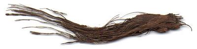 Coconut fibre (Smith's Cove)→
The artificial beach is one of the few elements of the alleged flood system that rests on direct physical observation confirmed by laboratory analysis. Multiple work crews across different eras saw it, removed material from it, and had that material tested. Whether it served as the intake for a flood tunnel or had some other function is a separate question.
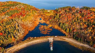
 Smith's Cove→
The Five Box Drains
Beneath the beach rocks, the Truro Company found five drains, each approximately eight inches wide, constructed from flat stones laid along the sides and across the top to form enclosed channels. The five drains fanned out from the edge of the high-water mark in a pattern described by every early chronicler as resembling the fingers of an open hand. Running back from the ocean and dropping deeper as they approached the shoreline, they converged on a single, larger drain just above the high-water mark.
An 1864 article in the Halifax Colonist, drawing on contemporary accounts, described the main drain in detail. The stones had been prepared with a hammer and laid so that the drain could not collapse. Multiple tiers of stones reinforced the upper section. A coating of eelgrass covered the top, followed by a layer of blue sand not found elsewhere on the island, and then the natural gravel of the coast. When the Truro men exposed a section of the main drain, they found it so well constructed that no earth had penetrated the arch.

The box drains are the second element of the alleged flood system supported by direct observation. Like the artificial beach, they were seen and described by multiple people across multiple expeditions. Their construction was clearly deliberate and skilled. What the Truro Company could not determine, and what no one has determined since, is where the main drain leads. The crew attempted to follow it inland but found the soil too waterlogged to continue. A storm then destroyed their cofferdam and reburied the drains in sand.
The Truro Company concluded that the drains fed a tunnel running to the Money Pit, roughly 500 feet to the west. That conclusion was logical given the observed flooding, but it was an assumption. No one from the Truro Company traced a continuous passage from the drains to the Pit.
 Box drains (fan-shaped)→
The Search for the Tunnel
If a tunnel connected Smith's Cove to the Money Pit, blocking it should stop the flooding. Multiple expeditions tried. None succeeded, and the evidence they produced for the tunnel's existence is less clear-cut than popular accounts suggest.
The Truro Company sank a shaft 140 feet from the Money Pit, on a line between the drains and the Pit, expecting to hit the tunnel at roughly 25 feet. They reached 75 feet without finding it. They moved 12 feet south and dug to 35 feet before hitting a boulder. As they pried it loose, saltwater rushed in, filling the shaft to tide level within minutes. This proved a water connection existed at that point, but not that it followed a single engineered passage.
In 1862, the Oak Island Association dug Shaft 8 near Smith's Cove specifically to intercept the tunnel, reaching 50 feet without finding one. They dug lateral tunnels in several directions. No tunnel was located. They then packed the box drains at Smith's Cove with clay and observed that the Money Pit water became muddy, which they took as proof of a connection. The water flow slowed but never stopped.
The Halifax Company, operating from 1866 to 1867, sank Shaft 10 roughly 200 feet southeast of the Money Pit and dug lateral tunnels from 110 feet. According to the company's records, one tunnel reached what was described as the entrance of the flood tunnel: a passage four feet high, two and a half feet wide, filled with round stones, and set on an upward angle of 22.5 degrees toward the ocean. This remains the most detailed description of the alleged flood tunnel in the historical record. It has not been independently verified, and no modern excavation has confirmed it.
It is also worth noting what Amos Nauss, who worked on the island for Professor Hamilton in the late 1930s and early 1940s, told investigators: "When we were down there, there was always saltwater coming in. But we could not find where it was coming from. We never saw the flood tunnels."
The South Shore
In 1898, Frederick Blair's Oak Island Treasure Company performed a test that changed the picture. The crew pumped Shaft 18 full of water well above tide level, expecting the overflow to appear at Smith's Cove. It did not. Muddy water emerged from three separate locations on the south shore of the island.
To confirm the result, Blair and his partners pumped the Money Pit full of water above sea level and dropped red dye into it. The dye appeared in the bay on the south shore, not at Smith's Cove.
In 1938, Professor Hamilton repeated the test, dropping dye into both the Hedden and Chappell shafts. His crew member Amos Nauss recalled taking a boat to the southeast side of the island, roughly a hundred yards offshore, where they could see the dye rising from the sea floor.
The 1898 and 1938 dye tests are among the most significant pieces of evidence in the Oak Island story, because they establish a water connection that runs in a different direction from the one every previous searcher had assumed. For 48 years, from 1850 to 1898, every effort to stop the flooding had focused on Smith's Cove. Blair's test showed the water was also coming from the south. Whether it travels through an engineered tunnel, through natural channels in the bedrock, or through ground destabilised by two centuries of excavation has never been determined.
Dan Blankenship reported physical observations that appeared consistent with a south shore connection. During the winters of 1979 and 1987, while overseeing pumping at the Money Pit, he reported seeing four large circular holes in the ice off the south shore, which he attributed to warm water rising from submerged openings. These observations have not been independently documented.
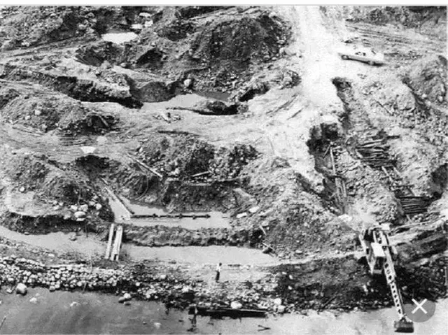
The Modern Excavation at Smith's Cove
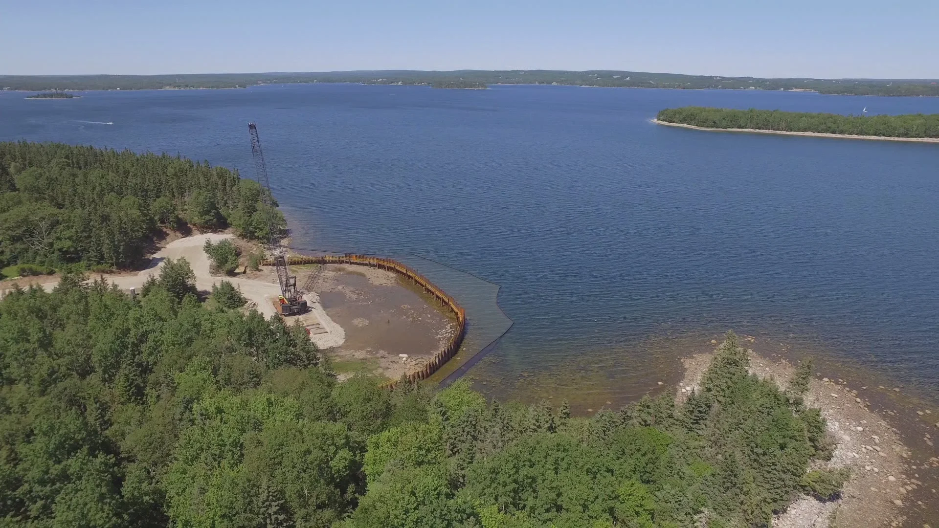
In 2018 and 2019, the Lagina team constructed a 525-foot steel cofferdam around Smith's Cove and pumped it dry, exposing the largest area of the cove that had ever been investigated. The operation produced a series of discoveries that both confirmed and complicated the historical accounts.
The U-shaped structure that Dan Blankenship had first encountered in the early 1970s was fully exposed. It proved to be a massive timber framework built from logs exceeding 24 inches in diameter, with Roman numeral carpenter's marks carved into the uprights. Dendrochronologist Dr. Colin Laroque at the University of Saskatchewan dated the wood to 1769 with what he described as 99.99 percent certainty, placing it 26 years before the discovery of the Money Pit.
Inside the U-shaped structure, the team found a previously unknown wooden wall made of thick offset timbers, along with stacked rocks and blue clay. Archaeologist Laird Niven identified the construction as consistent with a French drain, a system that channels water through gravity and gravel rather than enclosed pipe. This was a different type of construction from the flat-stone box drains found in 1850, and its relationship to the box drains has not been established.
A second timber formation, designated the L-shaped structure, was found parallel to the U-shaped structure. A slipway, apparently designed for hauling heavy loads, was also uncovered. Beneath the seabed, the team discovered a concrete wall roughly five inches thick with rubber tubes running through it, entirely unrecorded in any previous documentation. The wall's age and purpose remain undetermined.
The team searched for the convergence point where the five box drains were believed to meet the main flood tunnel. Trenches were cut and the area was excavated, but no additional box drains beyond the single one identified earlier in the season were found. The convergence point was not located.
 U-shaped wooden structure→
The 2019 Dye Test
During Season 6, the Lagina team conducted their own dye test. Red dye was mixed with up to half a million gallons of seawater and pumped into Borehole C-1 in the Money Pit area. Gary Drayton spotted red-coloured water seeping from the ground at Smith's Cove. Water samples were tested at the Oak Island Research Centre using a fluorometer capable of detecting dye at concentrations as small as one part per trillion. A reading above 1.0 would confirm the presence of dye. The Smith's Cove sample registered 11.98.
The test confirmed a water connection between the Money Pit area and Smith's Cove, as the 1898 and 1938 tests had confirmed a connection to the south shore. It did not prove the existence of a continuous engineered tunnel. Water can travel through fractured bedrock, disturbed ground from two centuries of excavation, or natural solution channels in the island's anhydrite and gypsum geology without requiring a purpose-built passage.
Natural Flooding
The assumption that the flooding is entirely the result of deliberate engineering has been challenged. The eastern drumlin of Oak Island sits on a geology of anhydrite and gypsum, materials that dissolve in water and form natural solution channels and cavities over time. More than two centuries of digging, from the original shaft through dozens of searcher tunnels, shafts, and boreholes, have thoroughly disturbed the ground between the Money Pit and the surrounding shoreline. Author Joy A. Steele and researcher Les MacPhie have argued that much of the flooding can be explained by natural water infiltration through this fractured and destabilised terrain, without requiring an engineered tunnel from Smith's Cove or anywhere else.
Season 13 of the show has focused heavily on the solution channel, a natural geological feature in the bedrock beneath the Money Pit area where the team believes treasure may have settled after the original shaft collapsed. The solution channel itself is not an engineered structure. It is a product of the island's geology. If natural channels can carry water, dissolved minerals, and even physical objects through the bedrock, the question of whether a separate man-made tunnel was needed to flood the Money Pit becomes less clear.
A Terminology Guide
The terms used to describe Oak Island's water features have shifted over 175 years of accounts, and different writers use them in different ways. For clarity:
Box drains (also called finger drains): The five stone channels discovered at Smith's Cove in 1850. Constructed from flat stones forming an enclosed rectangular passage roughly eight inches wide. These are physical objects that were directly observed.
Flood tunnel: The alleged main conduit running from Smith's Cove to the Money Pit, into which the box drains supposedly feed. Described by the Halifax Company in 1867 as four feet high, two and a half feet wide, filled with round stones. Never fully traced as a continuous passage.
South shore tunnel: The alleged conduit or conduits connecting the Money Pit to the island's south shore. Existence inferred from the 1898 and 1938 dye tests. Never physically observed.
French drain: A drainage construction that uses gravity and gravel rather than enclosed pipe to move water. The term was applied by archaeologist Laird Niven to stacked rocks and blue clay found inside the U-shaped structure during the 2018-2019 excavation. A different type of construction from the box drains.
Artificial beach (also called the filter bed or sponge): The layered construction of coconut fibre, eelgrass, and beach rocks found beneath the surface of Smith's Cove beach. Carbon-dated to 1260-1400 AD. Directly observed and scientifically tested.
U-shaped structure: The massive timber framework at Smith's Cove, first found by Dan Blankenship in the early 1970s and fully exposed in 2018-2019. Dendro-dated to 1769. Contains the French drain system. Not a drain itself but the infrastructure around whatever was happening at Smith's Cove.
Convergence point: The hypothetical location where the five box drains merge into the main flood tunnel. Sought by the Restall family and the Lagina team, among others. Never located.
What Can Be Established
The artificial beach at Smith's Cove existed. It was observed by multiple work crews, and the coconut fibre has been identified by the Smithsonian and carbon-dated to 1260 to 1400 AD. Five box drains made of flat stone, arranged in a fan shape, were found beneath the beach rocks by the Truro Company in 1850 and described in detail in an 1864 newspaper article. They converged into a larger stone drain heading inland. The U-shaped timber structure at Smith's Cove has been dendro-dated to 1769. Dye tests in 1898 and 1938 confirmed a water connection between the Money Pit and the south shore. A dye test in 2019 confirmed a water connection between the Money Pit area and Smith's Cove.
What has not been established: the existence of a continuous, engineered tunnel from Smith's Cove to the Money Pit; the existence of a separate engineered tunnel from the south shore; the location of any gate, valve, or control mechanism within the alleged flood system; the convergence point of the box drains; and the identity, era, and purpose of whoever built the infrastructure at Smith's Cove.
The box drains and the artificial beach are among the most compelling pieces of evidence that skilled, organised construction took place on Oak Island before 1795. The coconut fibre dates suggest this activity could have begun as early as the 13th or 14th century. The dendrochronology dates place the U-shaped structure in 1769. Whether these represent the same construction campaign, separated phases of work by the same builders, or entirely separate projects by different groups, the physical evidence alone cannot say. And whether the box drains ever fed a working flood tunnel, or whether the Money Pit floods for reasons that have more to do with geology and 230 years of digging than with deliberate engineering, is a question that remains open.