Long before the Lagina brothers, before the Onslow Company, before Daniel McGinnis found that depression in the ground in 1795, someone else may have stood on the shores of Oak Island. The Norse.
We know for certain that Viking explorers reached North America around 1000 AD. The question is how far south they travelled, and whether Oak Island bears the marks of their presence.
The Proven Foothold
In 1960, Norwegian explorer Helge Ingstad and his archaeologist wife Anne Stine discovered the remains of a Norse settlement at L'Anse aux Meadows on the northern tip of Newfoundland. Excavations revealed the foundations of eight buildings, including a forge, a carpentry workshop, and several dwellings. Radiocarbon dating placed the settlement around 1000 AD.
It was the first confirmed evidence of European presence in the Americas, nearly 500 years before Columbus. UNESCO designated it a World Heritage Site in 1978.
L'Anse aux Meadows sits roughly 1,200 kilometres northeast of Oak Island. For a civilisation that routinely crossed the open North Atlantic between Scandinavia and Greenland, that distance was well within reach.
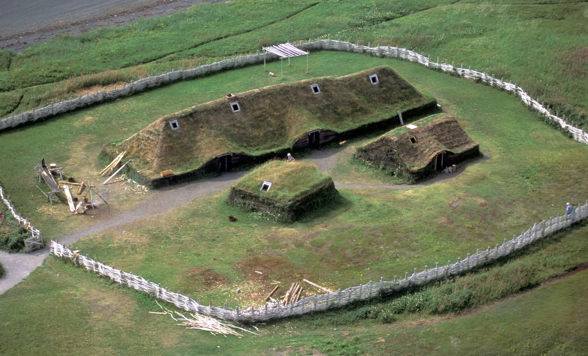 L'Anse aux Meadows→
The Stepping Stones
The Norse did not cross the Atlantic in a single leap. They followed a chain of islands and coastlines, each hop short enough to be completed in a matter of days. From western Norway to Shetland is roughly 300 kilometres. From Shetland to the Faroe Islands, another 300. From the Faroes to eastern Iceland, around 430 kilometres. From Iceland to Greenland's east coast, about 300 kilometres at the narrowest point. From western Greenland to Baffin Island and then south to Labrador and Newfoundland, the distances were shorter still. At no point was a crew out of sight of land for more than a few days. The Atlantic was not an abyss to be crossed. It was a corridor to be walked, one island at a time.
The sagas confirm this. Erik the Red sailed from Iceland to Greenland around 982 AD and spent three years exploring its western fjords. His son Leif followed the coast south to Newfoundland around 1000 AD. Thorfinn Karlsefni brought 160 settlers along the same route a few years later. Merchant ships continued travelling between Greenland and Labrador for centuries afterward. A Norse vessel sailed from Greenland to Markland to gather timber as late as 1347, more than three hundred years after the first crossing. This was not exploration. It was a trade route.
Before the Norse
The Norse were not even the first Europeans to use it. When they arrived in Iceland around 870 AD, someone was already there. The Icelandic chronicle Íslendingabók, written by Ari fróði in the early twelfth century, records that "Christian men, whom the Norse called papar, were here; but afterwards they went away, because they did not wish to live here together with heathen men." The Irish monk Dicuil, writing in 825 AD in his Liber de Mensura Orbis Terrae, described clerics who had lived on a northern island where the midnight sun allowed them to pick lice from their shirts at night. The island was almost certainly Iceland.
The place-name evidence supports the texts. Across Iceland, 146 locations carry names derived from kross, kirk, or papa, words signifying a Christian presence. The Norse who arrived as pagans would not have coined these names. They inherited them. In southern Iceland, archaeologist Kristján Ahronson documented rock-cut crosses in the Seljaland caves and used tephrochronology, the dating of volcanic ash layers, to establish that cave construction at the site began around 800 AD, significantly before the traditional date of Norse settlement. The cross forms themselves show parallels not with Scandinavian art but with early Christian sculpture from western Scotland and the Hebrides, suggesting a Gaelic monastic origin.
On Heimaey in the Westman Islands, Swedish archaeologist Margrét Hermanns-Audardóttir excavated a site that revealed at least ten structural phases beneath a fourteenth-century Norse farmstead. Carbon-14 dating placed the earliest habitation roughly 250 years before the Norse arrived. These were not hermits passing through. These were communities who farmed, built shelters, and stayed for generations.
In 1976, British navigation scholar Tim Severin proved the route was viable even with primitive technology. He sailed a replica leather currach, built to the specifications described in the ninth-century Navigatio Sancti Brendani, from Ireland to Newfoundland via the Faroes, Iceland, and Greenland. Between the Faroes and Iceland his crew made 120 miles in twenty-four hours. If sixth-century monks in a hide boat could reach North America, the later Norse in their oak-built longships certainly could.
The Sagas and the Lands Beyond
Two Icelandic sagas describe the Norse exploration of lands west of Greenland. The Saga of the Greenlanders and the Saga of Erik the Red tell of Leif Erikson's voyages to places he named Helluland (likely Baffin Island), Markland (likely Labrador), and Vinland, a land of wild grapes and mild winters.
The location of Vinland has been debated for over a century. Some scholars place it in Newfoundland. Others argue that the description of wild grapes, self-sown wheat, and warm temperatures points much further south, possibly to Nova Scotia, New Brunswick, or even New England. If Vinland was Nova Scotia, the Norse would have sailed directly past Mahone Bay and Oak Island.
The sagas also describe subsequent voyages by Thorfinn Karlsefni, who attempted to establish a permanent settlement in Vinland with a crew of around 160 people. They stayed for several years before conflicts with the indigenous population forced them to leave. These were not quick raids. The Norse came to stay.
The Land of White Men
The sagas contain one more detail that has never received the attention it deserves. Landnámabók, the Icelandic Book of Settlements, records that an Icelander named Ari Marson "sailed on the ocean to Hvítramannaland, which some call Írland Mikla, lying away west in the ocean near Vinland the Good, which is said to be six days' sail due west from Ireland. Ari could not get back from that country, and was baptized there." The story was corroborated by multiple sources: Hrafn the Limerick Trader, who had heard it from merchants in Ireland, and Earl Thorfinn of Orkney, who confirmed that Icelanders had recognized Ari in that land and that he had become a chieftain there.
The Annals of Greenland, an eleventh-century Norse chronicle, placed Hvítramannaland geographically: south of Greenland lay Skraeling country, then Markland, then Vinland the Good. "Next to it and a little beyond lies Albania, which is Hvítramannaland." The name itself is telling. Hvítramannaland means Land of White Men. Írland Mikla means Greater Ireland. The Norse were not describing an empty wilderness. They were describing a place where European Christians already lived. As Farley Mowat argued in The Farfarers, these were likely the descendants of the same papar who had been displaced from Iceland, people who had been pushed steadily westward by each new wave of Norse expansion.
The implication for Oak Island is significant. If European settlers were already living near Vinland before Leif Erikson arrived around 1000 AD, the window of possible European activity in Nova Scotia opens much wider than the conventional Viking Age narrative allows.
Evidence in Nova Scotia
Several finds in and around Nova Scotia have fuelled speculation about Norse activity in the region.
A Norse penny, minted during the reign of King Olaf III of Norway (1067-1093), was discovered at the Goddard site in Brooklin, Maine in 1957. While some researchers believe it arrived through indigenous trade networks, others see it as direct evidence of Norse contact along the northeastern seaboard. Either way, it confirms that Norse objects were circulating in the region.
The Yarmouth Stone, found in southwestern Nova Scotia in 1812, bears markings that some researchers have interpreted as runic inscriptions. The interpretation remains disputed, with others reading the marks as natural weathering or later carvings. But the stone has kept the question of Norse presence in Nova Scotia alive for over two centuries.
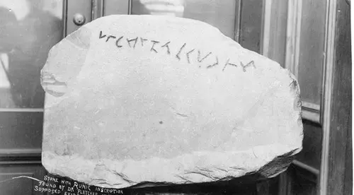 Yarmouth Runic Stone→
Four Centuries of Presence
The popular image of the Vikings as brief visitors, arriving around 1000 AD and quickly departing, obscures a much longer history. Norse Greenland endured for nearly five centuries. The Eastern Settlement persisted until at least the mid-1400s, supported by twelve churches, an Augustine monastery, a Benedictine nunnery, and a cathedral at Gardar. The Western Settlement, closer to the North American coast, survived until the mid-1300s. Throughout this entire period, ships sailed between Greenland and the lands to the west.
Around 1112 to 1118, Bishop Eric Gnupsson made a prolonged visit to the Vinland region, an ecclesiastical mission to lands the Norse had known about for over a century. In 1347, an Icelandic annal recorded a Norse ship arriving from Markland, Labrador, having sailed there from Greenland to gather timber. Between 1380 and 1400, the Zeno voyages reportedly reached Labrador, Newfoundland, and Nova Scotia. These are not isolated incidents. They are evidence of sustained, centuries-long Norse familiarity with the coastline that includes Oak Island.
Oak Island Connections
On Oak Island itself, several discoveries have been examined through the lens of possible Norse origin.
A crossbow bolt recovered during excavations caught the attention of researchers because crossbows were common weapons among Norse warriors and remained in use across Scandinavia well into the medieval period. The style and construction of the bolt raised questions about its age and origin.
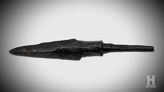 Crossbow bolt (Wroclawski/Dunfield)→
Wooden structures found deep in the Money Pit and surrounding shafts have been carbon-dated to periods that overlap with the known range of Norse exploration. While carbon dating provides a window rather than a precise date, and the wood could have been placed at any point after the tree was felled, the dates have kept the Norse theory in the conversation.
Stone markers and carved features on the island have also drawn comparisons to Norse navigational traditions. The Norse were known to use stone cairns, directional markers, and landscape features to guide their movements across unfamiliar territory. Some researchers see echoes of these practices on Oak Island, though separating Norse construction methods from later European ones is notoriously difficult.
The Engineering Question
One of the strongest arguments against the Norse theory is the sheer complexity of Oak Island's underground works. The Money Pit, the flood tunnels, the carefully layered platforms of logs, charcoal, putty, and coconut fibre: this was sophisticated engineering on a massive scale.
Were the Norse capable of it? The answer is more nuanced than it might seem. The Norse were exceptional builders. They constructed ocean-going longships capable of crossing the Atlantic. They built elaborate stave churches with intricate joinery and no nails. In Scandinavia, they dug extensive mining tunnels and constructed complex drainage systems.
But the coconut fibre found at Smith's Cove presents a problem. Coconuts do not grow anywhere near Scandinavia or the North Atlantic. Their presence on Oak Island suggests contact with tropical regions, which points more naturally toward later European powers with global trade networks, such as the Templars, the Spanish, or the British.
Unless, of course, the coconut fibre represents a separate and later phase of construction, added to works that were originally begun by someone else entirely.
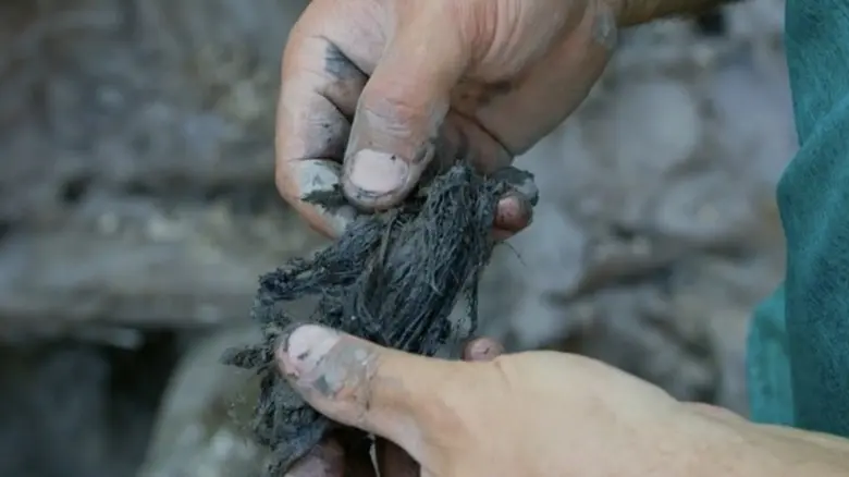 Coconut fibre (Money Pit)→
Norse or Not?
The Norse theory for Oak Island occupies an interesting middle ground. We know the Norse were in North America. We know they were capable sailors, skilled engineers, and prolific explorers. We know they travelled through waters that would have taken them within reach of Nova Scotia.
What we lack is the single definitive artefact: a clearly Norse object, recovered from a sealed context on Oak Island, with no possibility of later placement. Without that, the Norse theory remains compelling but unproven.
It is worth noting that the same could be said of most Oak Island theories. The island has a way of offering just enough evidence to keep every possibility alive, and never quite enough to settle the question.
If the Norse did reach Oak Island, they would have found exactly what every treasure hunter since has found: a small, wooded island in a sheltered bay, with deep soil and natural drainage, surrounded by the cold waters of the Atlantic. A place worth hiding something. A place worth remembering.